
Long Awaited and Debated Trinity River Vision Finally Gets Federal Funding — Fort Worth’s Own Waterfront Fairytale Comes True?
$403 Million Secured to Divert Potential Flood Waters, Open Up a Massive Swath of Land
By Courtney Dabney //

Fort Worth residents have heard tales of a mythical place called Panther Island or Central City and its promised urban waterfront/riverwalk for years. The Trinity River Vision has long promised an enhanced trail system, a scenic riverwalk, new shopping, dining and residential development in a long forgotten stretch of acreage.
Now, the office of U. S. Representative Kay Granger has revealed that the last piece of the federal funding puzzle has finally locked in. The bypass channel, which will create Fort Worth’s Central City (the formerly named Panther Island), is finally seemingly set to be turned into a reality. The $403 million has been secured.
This is big news on the banks of the Trinity River — and the rest of North Texas. Here’s the background on the massive project:
The Great Flood
In 1949, flood waters breached the banks of the Trinity River. The West Seventh Corridor — essentially from the Monticello neighborhood and what is now the Museum District stretching toward downtown — and large swaths of the city were completely engulfed by flood water. That includes what is now Crockett Row, Montgomery Plaza and The Foundry District. All were under water. People were rescued by fishing boats.
Massive property damage and losses rocked Fort Worth, at least 10 people died and some 13,000 were left homeless as a result.
The same flood also swelled into the largely warehouse district below downtown.
Top Father's Day Gifts


.png)
.png)
.png)
.png)
.png)
.png)
.png)
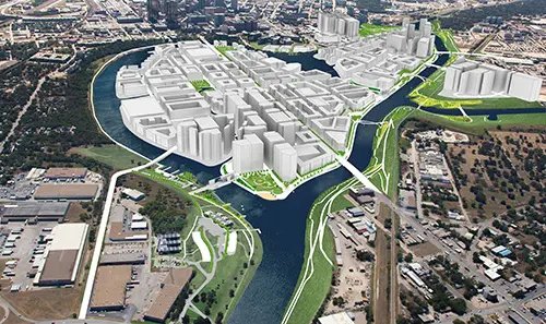
This devastating flood is the reason there is essentially a dead space, a massive 800 acres devoid of development — aside from rotting warehouses — running from the Tarrant County Courthouse as you cross the Trinity River on Main Street and head down to the North Side District. The reason is water. The potential of flood waters to be exact.
That’s why the levee system was conceived and built in 1960. During my lifetime, I’ve only known the Trinity surrounded by its levees ― holding future flood waters at bay. The great flood of 1949 revealed Fort Worth’s vulnerability, and city leaders and the Corp of Engineers have been working to manage it ever since.
The levees solved one problem by holding the Trinity within higher banks, but the levee system also isolated Fort Worth residents from one of the city’s best features ― the river itself. These levees are not likely to secure the city from the inevitable once-in-a-century flood, like the one in 1949, anyway.
The Corp of Engineers has deemed the levee system insufficient to protect Fort Worth as its population has swelled, more than tripling from what it was in 1960. What to do next?
The Trinity River Vision
The long process to get to the promised wonderland of Panther Island/Central City ― that near mythic flood-protected zone, where development could flourish by the banks of the Trinity — began with an idea U. S. Representative Kay Granger had while she was still serving as Fort Worth’s Mayor. A way to ensure flood safety that is designed to provide a boon to the Fort Worth economy at the same time.
It was formalized into the Trinity River Vision (TRV) in 2003, when the first draft renderings were released to the public, the potential mockups were touted and the “vision” was bought into by Fort Worth city leaders.
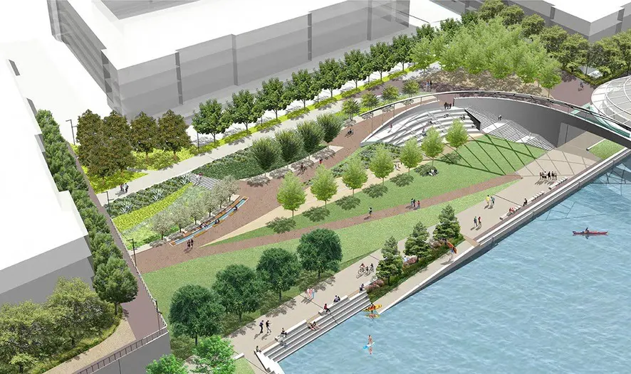
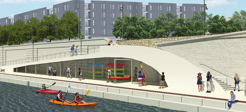
Under the plan, Fort Worth would have a bypass channel to redirect the Trinity River, alleviating future flood waters. It is designed to allow for flood-level water to be diverted in the event of emergency. At the same time, it creates an island surrounded by the river, where a lush waterfront paradise would spring up. It almost seemed like a fairytale.
Then, came the reality. The boring intervening years of earth moving projects to lay the ground work, Corp of Engineers approvals and design tediousness, construction issues and delays —including “bridges to nowhere” messing up traffic flow — and funding disappointments as Granger attempted to eke out federal funds for the massive project bit by bit, year after year in Washington.
To be sure, it’s been a long slog. The last of the bridges finally opened to public transit last year. Myriad articles have been written deriding the project. Earth moving ain’t sexy. The promise of development and the necessity of flood abatement were conjoined, muddying the waters even further. Many wondered if the project would ever get the needed funding to complete the original vision. But Granger plodded on. She has moved heaven and earth to see this Trinity River Vision through.
Granger, the Republican leader of the House Appropriations Committee, issued a statement on Wednesday after the U.S. Army Corps of Engineers released a work plan that includes $403 million for the Trinity River Vision/Central City flood control project.
“This is a great day for Fort Worth,” she says. “Having experienced unprecedented growth since I was mayor, we are now the 12th largest city in the nation. But with growth comes responsibility. As the leaders in flood control, I thank the U.S. Army Corps of Engineers for understanding that responsibility and addressing that need for Fort Worth. Our community will be safer thanks to their hard work and tireless commitment.”
The design will restore to Fort Worth more than 800 acres of currently underutilized land, what has long been a dead zone stretching between downtown and The Stockyards. It’s no longer just a fantastical fairytale.
Trending
- il Bracco Owners to Open New All-Day Restaurant Overlooking Katy Trail at Dallas’ Knox Street
- Where To Eat In Houston During the World Cup — 24 Restaurants That Show Off the Best of the Bayou City
- Nick & Sam’s Co-Founder Joseph Palladino Debuts New Modern Steakhouse in Dallas’ Preston Hollow
- Houston’s World Cup Entertainment Land Pitch Live Makes a Rocking First Impression — A Nightly Soccer Party Like No Other
- The Best Places To Shop In Houston During the World Cup — The Galleria Mall, River Oaks and More Must-Visit Stores


_md.jpg)

_md.jpg)


_md.jpg)

_md.jpg)